On a recent visit to the Westfries Archief, I found the first mention of Bruno Zee in the records of Medemblik. On May 29th, 1734, Bruno (noted as Bruine Seekamp; this is before he shortened his name to Zee) rented a house owned by the city of Medemblik, on the south side of the old harbour, for 1 guilder per month. The house was previously occupied by Annetje Elemants.

This tells us the specific date that Bruno moved to Medemblik from Bremen – which we guessed might have indeed been in 1734, but now we know for sure.
But where exactly was this house? The concept of streetnames and numbers as location identifiers would not come into popular use until later in the 18th century. Until this time, houses were usually referred to as being between two other known parties – with x person to the west, and y person to the east, or something like that.
Beginning around 1825, Holland created a huge land registry (Het Kadaster). It would be interesting to see if we can find a trace of a Zee/Seekamp descendant of Bruno in this area.
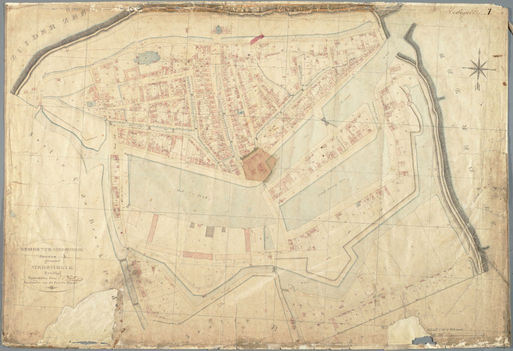
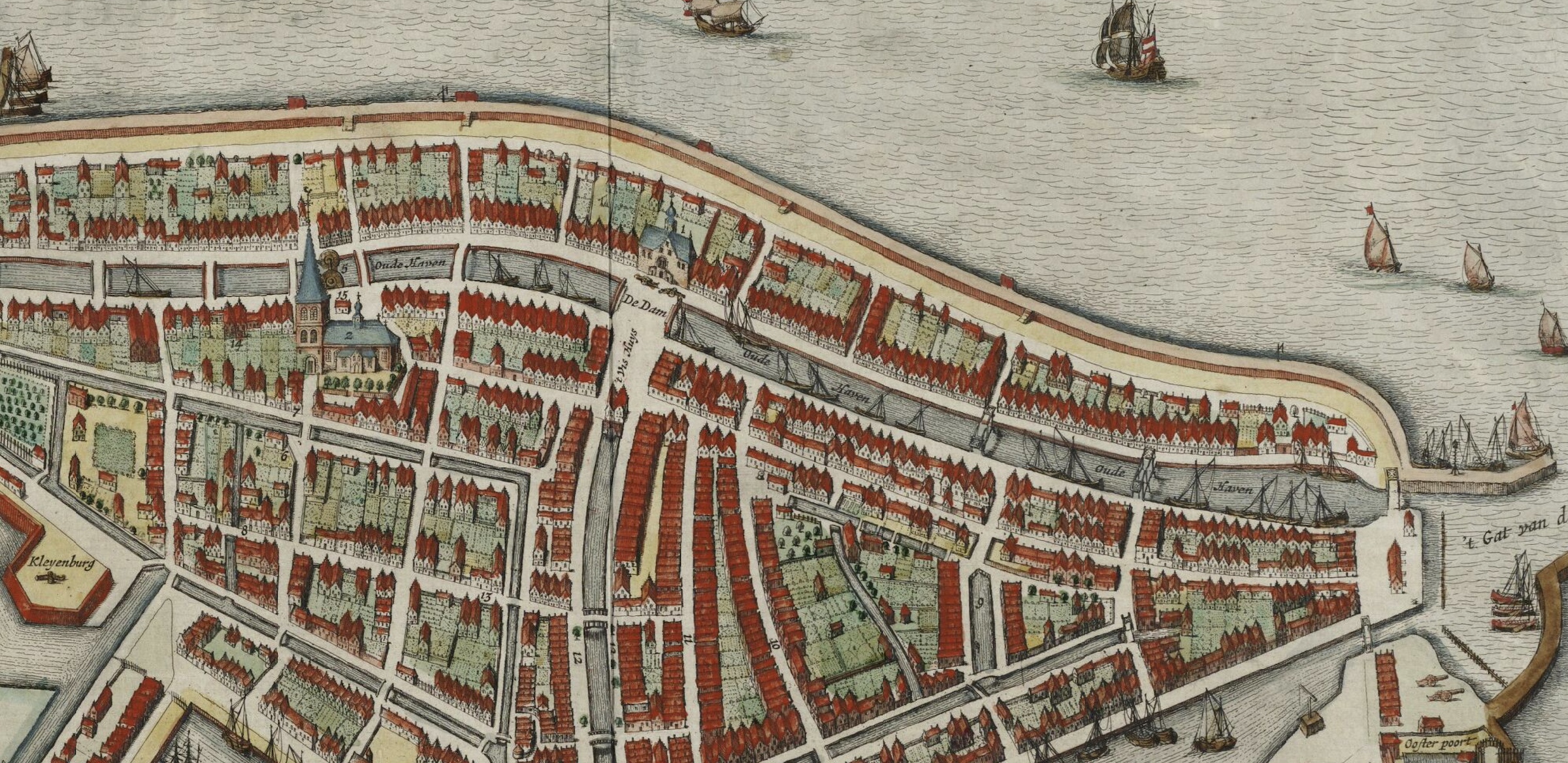
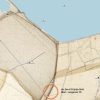
The above map is from 1825, which shows the Oude Haven area. The Erfgoed Beeldbank > has unindexed entries for Medemblik. Entry 169 & 176 match the map for the Gereformeerde Weeshuis, so we can look in the 1200’s for the area around Bruno’s house and see. Perhaps even if his name isn’t mentioned, some known neighbours might be. Further, we know that Bruno had some land beside the city’s Turfhuys, so that might well show up.
The houses of the south side of the harbour
For some reason, the idea of recreating the lay of the land in this part of Medemblik around 1800 is appealing, so I’m going to dig in and see what it looks like.
Oostersteeg – North side (1825)

The largest pieces of land on the south side of the Old Harbour are above. The kadaster lists indicate who owns what > (and what it is).
1201 Jan de Boer, Arbeider, house and garden, 2 roeden 70 ellen
1202 idem, house, 40 ellen
1203 Jacob Vegeters, Landman, Moetland, 13 r. 60 e.
1204 idem, house, 30 e
1205 Jacob Vos, nimalvader?, House, 23 e.
1206 idem, Meadow
1207 idem, Shed
1208 idem, Meadow
1209 Sijmen Jongert, kranteman, House & land, 01r45e
1210 Klaas Zon, sjouerman, House & land, 01r 53e
1211 Cornelis Meijer, metselaar, House, 76e
1212 Pieter Boker, Timmerman, Schuurtje, 31e
1213 idem, tuin
1214 idem, huishof
1215 Hendrik Bagman, koopman, garden
1216 Israellitische Gemeente, kerkhof,
1217 Hendrik Bagman, koopman, schuur
That completes this portion of the south-side of the Old Harbour. Some interesting things right away: a lot of meadow and farmland right here in the city centre, together with some smaller houses owned by ordinary people – including Klaas Zon, a sjouerman, or a dock-hand. This was Bruno’s profession in later years, and also that of his grandson Jan Zeekamp. Jan Zeekamp died in 1812, when his address was noted as Bangaard Wijk 1 No. 110.
The Israeli churchyard is mentioned on Wikipedia >, as located on the corner of the Oude Haven and the Bangert – the same place. It was purchased in 1765. This serves to confirm that we’re looking at the right places here in 1830.
Bruno’s House
After three years living in rented accomodation, Bruno was able to buy his own house in Medemblik in 1737. It was also on the south side of the old harbour.
Coopt Bruijn Zee wonende alhier van de welgemakte Heer Mr. Cornelis Houttuijn in qualiteit als bobven bij publique veiling, een huijs staande aan de Zuijd Zijd van de Oude Haven binnen deze stadt belent Hendrik Raper ten westen.
The price was 42 guilders.
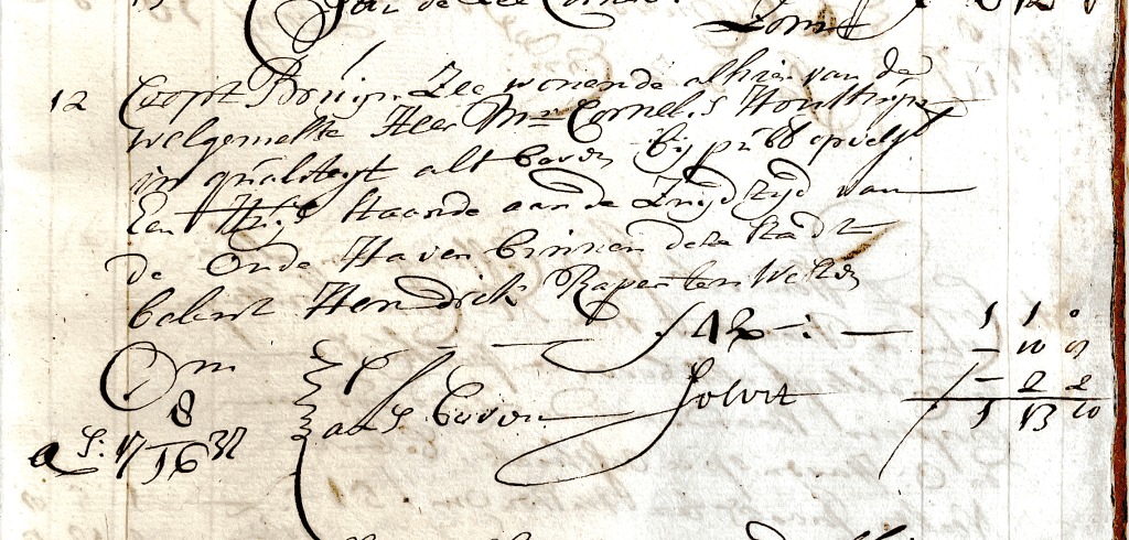
From this, we can see the first clue as to the location of the house: next door to Hendrik Raper, to the west.
On the same day, a man named Lucas Lucasz paid the taxes on his new house in the same area, for 18 guilders – his entry in the Gaarder book follows Bruno. There was only one person with this name in Medemblik, more correctly spelled as Lucas Lucassen. His wife was Lena Nieuwenhuijzen, and his full name was likely Lucas Lucassen Veen. As we can see from the baptism book below, Lucas was, like Bruno, a member of the Lutheran church. The Lutheran community was very small in Medemblik – mostly Germans who had emigrated here. In March of 1738, both Lucas and Bruno baptised their children Hijltje and Catharina (Trijntje) in the same week.
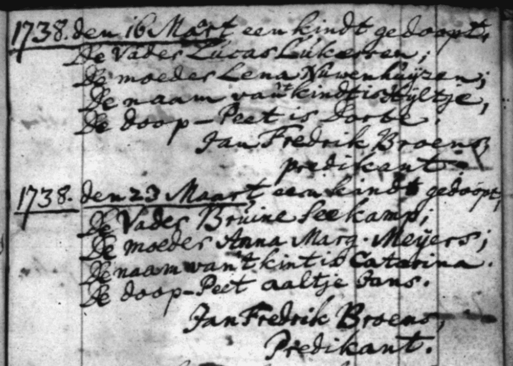
There is no question that Bruno and Lucas knew each other – same church, both with children of the same age, and living in the same area; from their joint visit to the tax office we can take a reasonable punt that they were friends. Lucas’s house was next door to Jacob Haan, to the east, and there is a note that it was occupied by the widow of Claas Stam (probably named Geertje Klaas >).
We know that in 1740 Bruno also was given a piece of land by the city, located beside the city’s Turfhuys. If we can find the Turfhuys on the 1825 map, it should be in the same location.
Zuid-Zijde Oude Haven 1730 onwards
In order to find the location of Bruno’s house, his neighbours, etc. – piecing together the puzzle.
Source: Memoriaal van de Stadt’s verhuurde huizen beginnende 1731
13-Jan-1731 Stijntje Cornelis huurt een huis bellent ten westen Henrik Raper
1-Jan-1732 Aan Matthijs v.d. Sluijten een huis gen. de Noorderpoort 20gl jaar.
12-Apr-1732 Aan Pieter Benedictus van Leeuwen de voorhuis van Nelisje Pieters staande beoosten de Rode Leeuw op de Oude Haven 16 gl.
3-May-1732 Aan Pieter Ankersz, een huis naast belent (het oude huis van) Anthonij de Smit ten oosten, en Henrik Raper ten westen, 15gl.
10-May-1732 Verkocht aan Casper Heitsje, een huis, belent Jacob Meindertsz ten oosten & een stads erf ten westen
21-Mar-1733 Aan Coenraat, het huijs daar Jan Broersz ingewoont heeft, naast Casper Heijtsica.
29-May-1734 Aan Bruno Seekamp van Bremen, een huis staande op de zuid zijde van de oude haven, bewoont bij Annetje Elemants, 1gl per month.
Source: Gaarder, 1737
All transactions in 1737 ref. Zuid Zijde Oude Haven
23-Mar-1737 Teunis Hermensz buys a house from Cornelis Houttuijn, belent Heijn van Dockum ten westen, fl. 50
23-Mar-1737 David de Vries buys a house from C.H., to the east of the one above, with a common field between them, fl. 40.
23-Mar-1737 Aagje Abrahams buys a house from C.H., lived in by the purchaser (Aagje Abrahams), fl. 39
10-Aug-1737 Claas Loote buys a house from Cornelis Houttuijn, z.z. van de oude have, belent erven Jacob Vos(Cos?) ten westen, bewoont bij Hendrik Covers fl. 68
12-Aug-1737 Bruijn Zee buys a house from the same “heer Mr. Cornelis Houttuijn”, een huis staande aan de z.z. van de oude haven, belent Hendrik Raper ten Westen, fl. 42
12-Aug-1737 Lucas Lucasz buys a house from “heer Mr. Cornelis Houttuijn, Thesaurier (Treasurer) bij publique obveijlinge van den Raathuijse”, z.z. oude haven., bewoont bij de wed. Claas Stam, fl. 18
14-Aug-1737 Neeltje Jacobs buys a house from C. H., bij haar gewoont, fl. 250.
14-Aug-1737 Hendrik Jansz Cassing [Havenmeester en brugmeester, sinds 1730 >] buys a house from C.H., een Pakhuijs en Comptoir, z.z. oude haven, op de Oosthoek, belent Neeltje Jacobs ten westen, fl. 51
15-Aug-1737 (J?)urge Tomas buys a house, z.z. oude haven, bewoont bij Joost Jacobsz, belent de Wed Claas Stam ten oosten, fl. 45
9-Sep-1737 Gerrit Haartman buys a house van Aagje Abrahams, z.z. oude haven, belent Heijn van Dockum den westen, en ten oosten ‘t pakhuijs van den Heer schepen Pieter de Zee, fl. 45
30-Sep-1737 Thijs van der Sluijten buys a house van C.H., z.z oude haven, bewoont door Hendrik Alberts, fl. 16
26-Oct-1737 Jan de Bos buys a house from C.H., z.z. oude haven, bewoont bij Jacob K(eb?), fl. 6
19-Dec-1737 Jan Hermentz de Vries buys a house and erf from Hendrik de Zee, z.z. oude haven, belent Hendrik Raper ten oosten en Lambert de Belemaker ten westen, fl. 18.
1738 Jan de Meyer buys a house from Jurge Thomas, z.z. oude haven, belent Lukkes Lukkesz ten oosten en Harmen Smit ten westen, fl. 60
1739 Hendrik de Wilde buys a house from Tijs van der Sluijten, een Wal en Huis, belent het pakhuis van Pieter de Zee ten oosten, en David de Vries ten westen, fl.60
1740 Pieter van der Wolff, raad in de Vroedschap en Secretaris dezer stad, koopt een huis van Neeltje Jacobs bejaarde dochter alhier, een huis staande z.z. oude haven, belent Teunis Schellingen ten oosten, en een pakhuisje van Jan Roos ten westen, fl. 600.
c. 1741 Hendrik Coover buys a house from Lucas Lucasz, belent Jacob Swan ten oosten, en Jan de Meijer ten westen, fl. 25.
31-Jan-1742 Dorte Jans buys a house from Jurriaan Kleijn, belent Cornelis Jans ten oosten, en Hendrik Swart ten westen, fl. 100
10-Apr-1742 Jacob Hogendijk buys land from Jacob Roosterman, z.z. oude haven, land 40 feet long, achter de stal van Isac van Gelder, belent het Stats turfhuijs ten oosten, en Hendrik de Loijer ten westen, fl. 10.
Source: Memoriaal Burgemeesters
23-Jan-1734 De Heeren Burgemeesters verkocht aan Mattijs van der Sluijten het huis “de oranjeboom” staande aan de z.z. oude haven, belent het pakhuis van Pieter de Zee ten oosten, voor een somma van 4 gl.
“Resstante Verpond. en Recognt. en vervallents, 1740-1745 inc”
Mattijs va der Sluijte 1740-1745
Jasper Jansz 1745,
Lucas Lucasz 1744-45, fl. 7.20
Jurriaan Tomasz 1745, fl. 2.20
Harm Jans Recognt. 1745, fl. 5
Bruijn Zee 1740-1745 inc., fl. 15
Hend. Raaper 1744-1745, fl. 20
1746-1749 Ord. en Extra Verpond en Recognitie Vervallents
Ref No. 142 – Claas Lootes 1748 & 1749, fl. 7
146 – Lucas Lucas, 1746-1749, fl. 14
147 – Juriaan Tomas, 1746-1749, fl. 14
149 – Harmen de Smit, 1746-1749, fl. 20
150 – Bruijn Zee, verpond. en rep.. 1746-1749, fl. 14
154 – Hendrik Jans, fl. 18
192 – Abraham Bantjes, 11.50,
192 – Hendrik Raper fl. 60
02-Jan-1751 Burgemeesters hebben gegeven aan Joost Schuurman een Huijs, erfje en gront staande en leggende aan de zuijdzijd van de oude haven belent de rooleeuw ten oosten en ten westen een StatsStraatje, en een Stats erf naast erft van Bruijn Zee, mede niet ver van ‘t selve Huijs gelegen, mits al selve wel …
Location of the Stats Turfhuis
06-Feb-1734 De Heeren Burg. hebben verkogt aan Isak van Gelderen het huis laast bewoont door Diewer Jelis staande aan de zuid zijde van de oude haven bewesten den Dam, belent den koper ten oosten voor een somma van 4 gl. [>]
13-Oct-1736 De Heeren Burgemeesteren hebben op voorleden Mei aan Angemet Hermens verkogt een erfje gelegen achter het Statsturfhuis staande aan de zuidzijde van de oude haven bewesten de dam om een somma van 12 gl. … [>]
[Memoriaal van Burgemeesters, over allerlei zaken, 1722 tot 1757]
Reperatie Geld, 1734.
Oude Haven
